
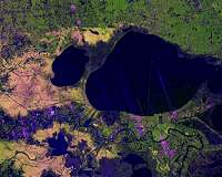
NISAR radar view maps surface changes in Mississippi Delta
Los Angeles CA (SPX) Feb 02, 2026
A new radar image from the joint NASA-ISRO NISAR satellite shows how the mission can see through cloud cover to reveal surface features across the Mississippi River Delta region in southeastern Louisiana.
The scene, acquired on November 29, 2025, with NISAR’s L-band synthetic aperture radar instrument, spans the cities of New Orleans and Baton Rouge, the winding Mississippi River between t
Published by SpaceDaily on 02/04/2026