Indian Space Research Organization NISAR (NASA-ISRO Synthetic Aperture Radar) GSLV Mk II
Rocket Launch Video Streams
Rocket Launch Timeline
Track every phase of the rocket launch with our detailed mission timeline. From T-minus countdown events and pre-launch preparations through liftoff, stage separation, and orbital insertion, follow each critical milestone in real-time. Our comprehensive launch sequence timeline includes payload integration, propellant loading, engine ignition, and post-launch telemetry tracking.
| View Complete Launch Timeline | |
|---|---|
| T- 00 : 00 : 05 | Ignition Start of the engine ignition sequence |
| T+ 00 : 00 : 00 | Liftoff First upwards movement of the rocket |
| T+ 00 : 02 : 29 | MECO Cut-off of the main engine |
| T+ 00 : 02 : 30 | SES Start of the second engine |
| T+ 00 : 02 : 31 | Stage 2 Separation Separation of the second stage from the first |
| T+ 00 : 02 : 51 | Fairing Separation Separation of the payload fairing |
| T+ 00 : 04 : 50 | SECO Cut-off of the second engine |
| T+ 00 : 04 : 53 | Stage 3 Separation Separation of the third stage from the second |
| T+ 00 : 04 : 54 | Stage 3 Ignition Third stage engine ignites. |
| T+ 00 : 18 : 21 | Stage 3 Cutoff Third stage engine shuts down. |
| T+ 00 : 18 : 36 | Payload Separation Final deployment of the payload from the rocket |
About the NISAR (NASA-ISRO Synthetic Aperture Radar) Mission
- Type: Earth Science
- Orbit: Sun-Synchronous Orbit
The NASA-ISRO Synthetic Aperture Radar, or NISAR satellite, will use advanced radar imaging to map the elevation of Earth's land and ice masses 4 to 6 times a month at resolutions of 5 to 10 meters. It is designed to observe and measure some of the planet's most complex natural processes, including ecosystem disturbances, ice-sheet collapse, and natural hazards such as earthquakes, tsunamis, volcanoes and landslides.
Under the terms of the agreement, NASA will provide the mission's L band synthetic aperture radar (SAR), a high-rate telecommunication subsystem for scientific data, GPS receivers, a solid-state recorder, and a payload data subsystem. ISRO will provide the satellite bus, an S band synthetic aperture radar, the launch vehicle, and associated launch services.
Launch Pad & Location
Satish Dhawan Space Centre Second Launch Pad
Satish Dhawan Space Centre, India
The Satish Dhawan Space Centre Second Launch Pad launch pad has hosted 32 rocket launches, including 31 orbital launch attempts. The Satish Dhawan Space Centre, India launch site has been the location for 103 total rocket launches.
Satish Dhawan Space Centre – SDSC (formerly Sriharikota Range – SHAR),[1] is the primary spaceport of the Indian Space Research Organisation (ISRO), located in Sriharikota, Andhra Pradesh.

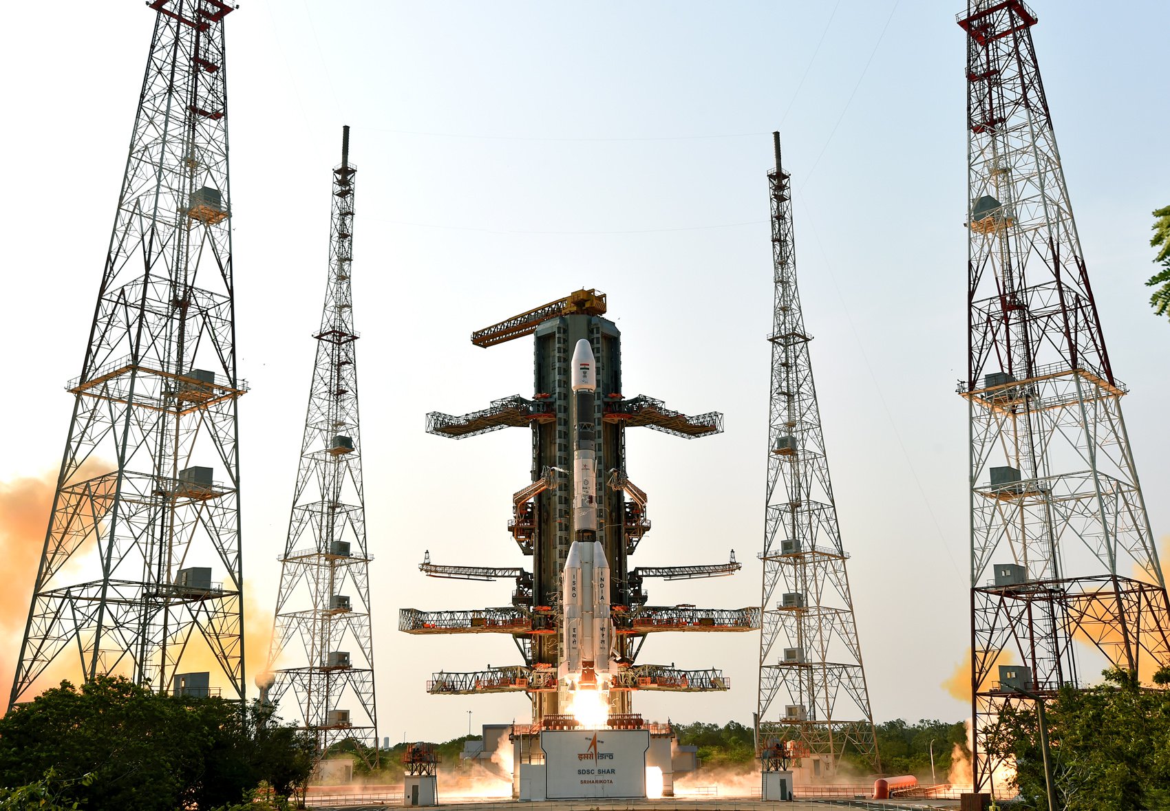
Indian Space Research Organization GSLV Mk. II Rocket
Geosynchronous Satellite Launch Vehicle Mark II (GSLV Mk II) is the largest launch vehicle developed by India, which is currently in operation. This fourth generation launch vehicle is a three stage vehicle with four liquid strap-ons. The indigenously developed cryogenic Upper Stage (CUS), which is flight proven, forms the third stage of GSLV Mk II. From January 2014, the vehicle has achieved four consecutive successes.
Learn more about the Indian Space Research Organization GSLV Mk. II Rocket
About Indian Space Research Organization
The Indian Space Research Organisation (ISRO) is the space agency of the Government of India headquartered in the city of Bangalore. Its vision is to "harness space technology for national development while pursuing space science research and planetary exploration."
Frequently Asked Questions
When was the Indian Space Research Organization GSLV Mk II NISAR (NASA-ISRO Synthetic Aperture Radar) launch scheduled?
The Indian Space Research Organization GSLV Mk II NISAR (NASA-ISRO Synthetic Aperture Radar) launch was scheduled for:
.
Where can I watch the Indian Space Research Organization GSLV Mk II NISAR (NASA-ISRO Synthetic Aperture Radar) launch video?
You can watch the Indian Space Research Organization GSLV Mk II launch video on this page. The official video includes full mission coverage with multiple camera angles, onboard views, and expert commentary covering pre-launch procedures, liftoff, stage separation, and payload deployment.
Where did the Indian Space Research Organization GSLV Mk II NISAR (NASA-ISRO Synthetic Aperture Radar) mission launch from?
The Indian Space Research Organization GSLV Mk II rocket launched from Satish Dhawan Space Centre Second Launch Pad at Satish Dhawan Space Centre, India. Satish Dhawan Space Centre – SDSC (formerly Sriharikota Range – SHAR),[1] is the primary spaceport of the Indian Space Research Organisation (ISRO), located in Sriharikota, Andhra Pradesh.
What rocket was used for the NISAR (NASA-ISRO Synthetic Aperture Radar) mission?
The NISAR (NASA-ISRO Synthetic Aperture Radar) mission launched aboard a Indian Space Research Organization GSLV Mk II rocket. Geosynchronous Satellite Launch Vehicle Mark II (GSLV Mk II) is the largest launch vehicle developed by India, which is currently in operation. This fourth generation launch vehicle is a three stage vehicle with four liquid strap-ons. The indigenously developed cryogenic Upper Stage (CUS), which is flight proven, forms the third stage of GSLV Mk II. From January 2014, the vehicle has achieved four consecutive successes. Detailed rocket specifications and performance data are available in the rocket details above.
What weather conditions could have delayed the Indian Space Research Organization GSLV Mk II NISAR (NASA-ISRO Synthetic Aperture Radar) launch?
The Indian Space Research Organization GSLV Mk II NISAR (NASA-ISRO Synthetic Aperture Radar) launch could have been delayed by various weather conditions including lightning within 10 nautical miles, high winds (especially upper-level winds), thick cloud layers, precipitation, and poor visibility. Weather must be favorable at the launch site, downrange landing zones, and abort landing sites.
How can I get updates if the Indian Space Research Organization GSLV Mk II NISAR (NASA-ISRO Synthetic Aperture Radar) launch was delayed?
This page was updated in real-time with the latest Indian Space Research Organization GSLV Mk II launch status, including any delays or scrubs for the NISAR (NASA-ISRO Synthetic Aperture Radar) mission. You can also check our space launch schedule for historical launch information. Our mobile app provides push notifications for instant alerts about launch status changes. Official Indian Space Research Organization live streams provided the most immediate range updates during the launch window.